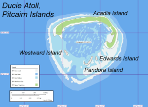
Ducie Island (/ˈduːsi/; Pitkern: Ducie Ailen) is an uninhabited atoll in the Pitcairn Islands group, which also includes Pitcairn, Henderson and Oeno islands. Ducie lies east of Pitcairn Island, and east of Henderson Island, and has a total area of 1.5 square miles (3.9 km2), which includes the lagoon. It is 1.5 miles (2.4 km) long, measured northeast to southwest, and about 1 mile (1.6 km) wide.[1] The island is composed of four islets: Acadia, Pandora, Westward and Edwards.
Despite its sparse vegetation, the atoll is known as the breeding ground of a number of bird species. More than 90% of the world population of Murphy’s petrel nests on Ducie, while pairs of red-tailed tropicbirds and fairy terns make around 1% of the world population for each species.
Ducie was first discovered in 1606 by Pedro Fernandes de Queiros, who named it Luna Puesta, and rediscovered by Edward Edwards, captain of HMS Pandora, who was sent in 1790 to capture the mutineers of HMS Bounty. He named the island Ducie in honour of Francis Reynolds-Moreton, 3rd Baron Ducie. In 1867, a claim on the island was made under the United States’s Guano Islands Act, but the claim was never bonded. The United Kingdom annexed the island on 19 December 1902 as part of the Pitcairn Islands. Due to its inaccessibility and the distance from Pitcairn, Ducie is rarely visited, receiving one or two visits a year from cruise ships.
Ducie lies 290 miles (470 km) east of Pitcairn Island and is claimed by some to be the southernmost atoll in the world at 24°41′ S latitude. However, Elizabeth Reef in the Tasman Sea is at 29°57 S latitude, so the assertion on behalf of Ducie Island is doubtful. Ducie Island’s land area is 170 acres (69 ha) and its maximum elevation, occurring on the Westward islet, is 15 feet (4.6 m).
Ducie is located 620 miles (1,000 km) west of the edge of the Easter Plate. It was formed approximately 8 million years ago, after Oeno Island was formed by a hotspot that later caused a magma leak generated in the Oeno lineation. The leak spread over fracture zone FZ2, which was formed by the third movement of the Pacific Plate. The atoll is part of the Oeno-Henderson-Ducie-Crough seamount, speculated to be part of the southern Tuamotus.
The atoll consists of four islets: Acadia—which is by far the largest—Pandora, Westward and Edwards. All three of the smaller islets can be accessed on foot from Acadia at low tide.[36] The islets were named by Harald Rehder and John Randall, who visited the atoll during an expedition by the Smithsonian Institution in 1975.
- Acadia Islet, along the atoll’s north and east rim, is several times larger than the other three islets combined, measuring 140 acres (57 ha). Very long and thin, the islet is largely forested and is composed of ridges of coral rubble. It is named after the Acadia, a ship that was wrecked on Ducie in 1881.
- Pandora Islet, in the south, is the second largest. It is composed of sand and coral rubble that borders the lagoon. It is named after HMS Pandora.
- Edwards Islet lies immediately to the east of Pandora Islet and has the same characteristics. It is named after Edward Edwards, captain of HMS Pandora.
- Westward Islet, west of Pandora Islet, is the smallest. It appears sandy from a distance, but the soil is composed of coral rubble and dead shells. Its highest point rises 15 feet (4.6 m) above average sea level. It is named after the Westward, the ship that carried the members of the National Geographic Society and the Oceanic Institute during their 1970–71 expedition.
The atoll has a central lagoon, accessible by boat only by way of a channel 100 yards (91 m) wide located in the southwest, between Pandora and Westward Islets. It has a maximum depth of 52 feet (16 m) and its bottom consists of sand and coral. Whirlpools in the lagoon are common, caused by caves that drain the water from the lagoon into the ocean.
Pandora is known as being one of the three coastline vertices for Point Nemo, the set of coordinates in the South Pacific Ocean that represents the furthest point from any land in three directions.
Flora
The vegetation in the atoll is sparse, because of the lack of fresh water. Only two species of vascular plant are currently known to grow there – one of the smallest such floras on any island. Acadia, Pandora and Edwards Islets are forested with Heliotropium foertherianum, but Westward Islet is not. Pemphis acidula has also been recorded on Ducie; specimens were found during an expedition in 1991.
During the expedition of Hugh Cuming in 1827 and the 1922 Whitney South Sea Expedition, Lepturus grass was found on Acadia Islet. However, it disappeared when storm waves deforested the island some time before the Smithsonian expedition of 1975. Thus H. foertherianum now dominates the vegetation of the islets. Additionally, there are a number of species of coralline algae, including Porolithon onkodes, Porolithon gardineri, and Caulerpa racemosa.
Fauna
The atoll is populated by several species of birds, fish, and reptiles. In the lagoon, sparse, living coral can be found; the dominant species is Montipora bilaminata (family Acroporidae). Most of the coral in the lagoon is dead, presumed to have been killed by influxes of cold water.
Birds
Though no terrestrial birds are found on the atoll, Ducie Island is known for the seabirds that breed there. Birds that have been recorded nesting on the atoll include the red-billed tropicbird, red-tailed tropicbird, white tern, great frigatebird, masked booby, and red-footed booby. Wintering bristle-thighed curlews have been recorded as well. A number of tern species, including the sooty tern, blue noddy, brown noddy, lesser noddy, and white tern have been recorded, as have several members of the family Procellariidae: Kermadec petrel, Trindade petrel, Murphy’s petrel, and Christmas shearwater.
The island is particularly important for Murphy’s petrel, as more than 90% of its world population breeds on Ducie. Around 3,000 pairs of Christmas shearwaters, about 5% of the world’s total population, can be found on the island too. Meanwhile, the red-tailed tropicbirds and white terns that breed on Ducie are around 1% of the world population of each species.Phoenix petrels, which previously inhabited the atoll, apparently disappeared between the Whitney expedition in 1922 and the 1991–92 Pitcairn Scientific Expedition.[26] The island has been identified by BirdLife International as an Important Bird Area (IBA), principally for its colonies of Murphy’s, herald, and Kermadec petrels, and Christmas shearwaters.
-
Fish
In the lagoon there are around 138 fish species, which also inhabit southeastern Oceania, the Western Pacific, and the Indian Ocean. The lagoon is noted for its poisonous fish and dangerous sharks. The yellow-edged lyretail, the blacktip grouper, and the greasy grouper are known to cause ciguatera poisoning. The lagoon is also inhabited by Galápagos sharks and the whitetip reef shark. The Galápagos shark is dangerous to humans, while the whitetips are seldom aggressive unless provoked. Five species are found exclusively around the Pitcairn Islands: Sargocentron megalops (a species of squirrelfish), the spiny butterflyfish, the Henderson triplefin (a species of threefin blenny), an unnamed species of Alticus (a genus of combtooth blenny), and an unnamed species of Ammodytes (a genus of sand lance).
Terrestrial vertebrates
Lizards that inhabit the island include the white-bellied skink (Emoia cyanura), photographed by E. H. Quayle during an expedition in 1922, and a lizard reported in the journal of an expedition in 1935 by James Chapin. The species of the latter was uncertain, but it was thought to be a gecko, possibly either an oceanic gecko (Gehyra oceanica), or a mourning gecko (Lepidodactylus lugubris). The 1991–92 Pitcairn Islands Scientific Expedition found specimens of both the mourning gecko and the white-bellied skink. The only mammal known to inhabit Ducie is the Polynesian rat; In 1997, there was a successful project to eradicate these by Brian Bell (WMIL) and Graham Wragg (S/V Te Manu), to aid the conservation of bird species threatened by the rat population. Green sea turtles feed on Ducie, but have not been seen to breed there.